The first Australians were Lévy walkers

- Hunter-gatherers don’t move in straight lines but in patterns called “Lévy walks.”
- Early migrations didn’t occur in static environments — they changed with the climate.
- Based on those two insights, a new model for the peopling of Australia claims predictive power for other migrations.
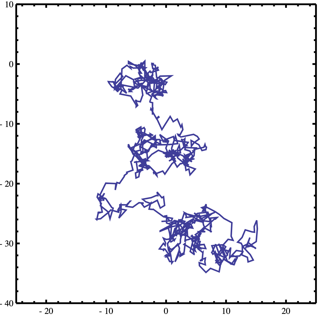
If you’re a band of hunter-gatherers entering a new land, you don’t move in straight lines — you progress in a pattern called “Lévy walks”. Where you go, and how quickly, is determined by the lay of the land, and how it changes over time.
Sahul, before it shrank and fragmented
Those two insights are the pillars upon which Australian and French researchers have built a new model for mapping how pre-agricultural humans occupied new territory.
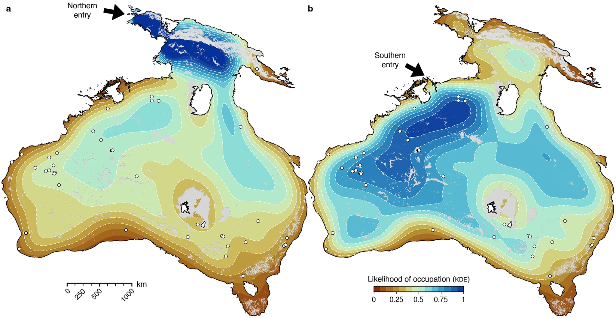
They’ve applied it to Sahul, a paleocontinent that included present-day New Guinea, Australia, and Tasmania. The model works so well that it can be used to predict the location of archaeological sites, not just in Australia, but anywhere it is used.

Sahul had its greatest extent about 65,000 years ago when global coastlines were about 85 m (280 ft) lower than today. This was during the last Ice Age when much more water was stored away in glaciers. As the planet warmed and those glaciers started melting, Sahul shrank and fragmented. New Guinea separated from the Australian mainland about 8,000 years ago, and Tasmania became an island roughly 6,000 years ago.
Quite different from today’s Australia
The first humans crossed over into this part of the world much earlier, when it was all still one joined-up continent. Scientists have established two likely migration events:
- The first one occurred around 75,000 years ago, with people crossing over from Bali and Timor to what is now known as the Kimberley region of northwest Australia. This is the so-called southern route.
- Roughly 2000 years later, a second group wave came over via a northern route: from Borneo to the Vogelkop Peninsula in northwest New Guinea.
Those earliest arrivals found a place that was quite different from today’s Australia. Sahul back then contained a rich variety of ecological zones, from tropical rainforests and deserts to subtropical grasslands, temperate forests, and regions with an alpine climate.
Moving through shifting landscapes
It was only after the end of the last Ice Age that Australia acquired its now typical vast and arid inland deserts. By that time, the Aboriginal people were already firmly implanted in the Australian interior and managed to adapt to the changing environment.
But how did they get there, and when? As detailed in a recent article in Nature, the authors of the new migration model (from the University of Sydney, Southern Cross University, Flinders University, and Université Grenoble-Alpes) applied two innovations to the field of migration simulation.
Firstly, they considered how people would have moved through these shifting landscapes: in seemingly random but actually rather purposeful patterns called “Lévy walks,” named after the French mathematician who first described them. This mobility pattern has been largely overlooked when simulating how early humans dispersed and occupied new lands.
Short, seemingly random excursions
A Lévy walk consists of short, seemingly random excursions in a relatively small zone, with an occasional much longer trip outside that base area. This pattern of movement is an excellent foraging method and has been observed both in animals and present-day hunter-gatherers in southern Africa.
The researchers also carefully read the prehistoric weather report, factoring in the effects of rainfall and sea level variation on river courses, erosion, and the transport of sediment on the speed and direction of migration. This stands in contrast to most migration models, which simply assume that landscapes are static and don’t recognize the impact of climate-driven changes, such as shifting river systems, on the human settlement of a continent.
Changing camp more than 30 times a year
Some examples of how climate and mobility patterns interact:
- Hunter-gatherer movements are determined more by necessity than intention. Daily foraging trips can vary from 2 to 15 km (1.2 to 9.3 miles), but will occasionally be around 25 km (15.5 miles). Aboriginal foragers would often make even longer trips and accept a low caloric intake if it meant they could return to a secure water source.
- It can be tricky to distinguish foraging (i.e. returning to base camp) from migrating (i.e. setting up camp elsewhere), because those residential moves vary so much between groups, also depending on the environment. The Anbarra from Arnhem Land will move only a few times a year, and over relatively short distances, while the Ngadadjara of the western desert change camp more than 30 times a year, often more than 40 km (25 miles) each time.
5,000 migration paths
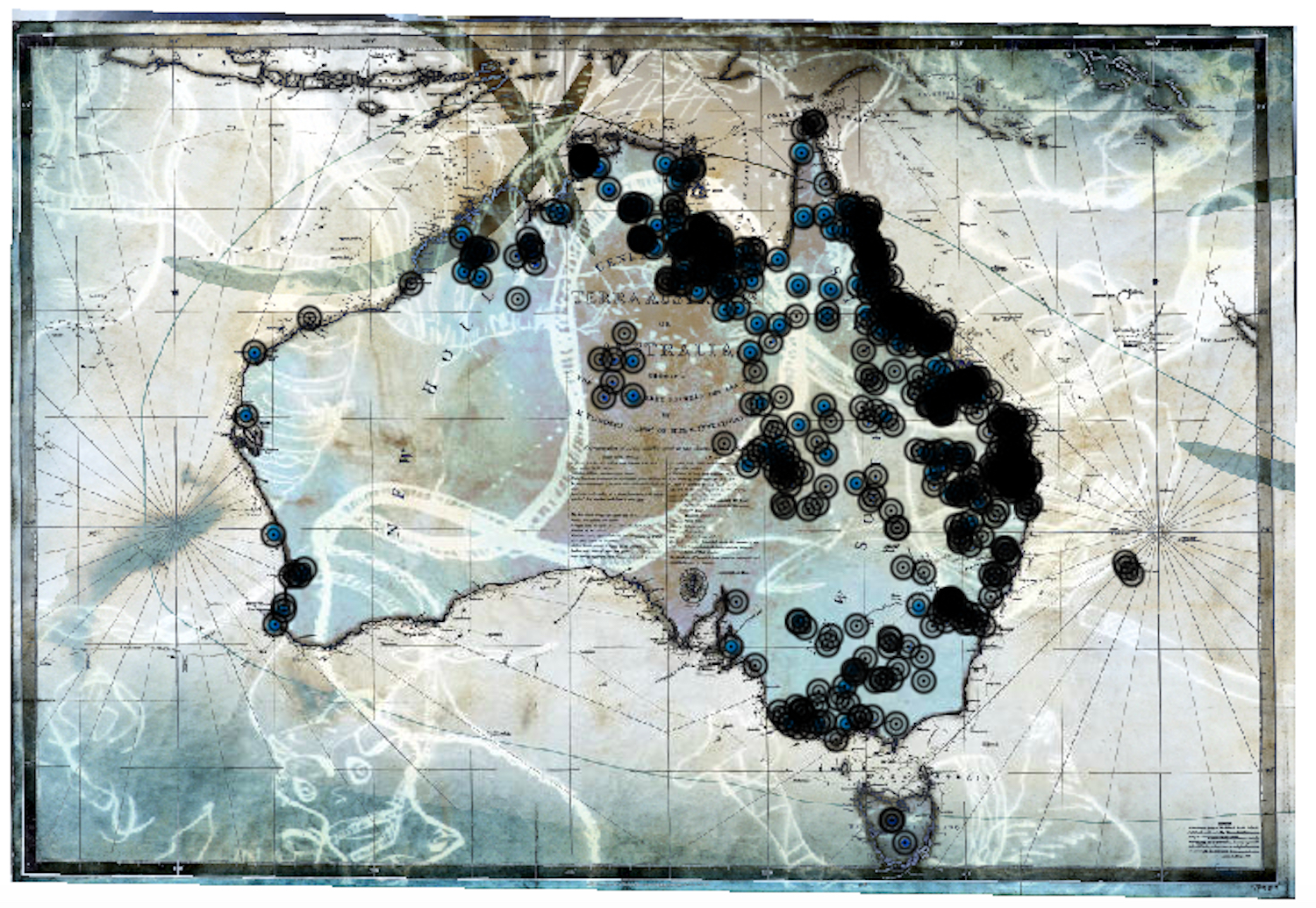
So, rather than work with a unique mobility radius, the researchers combined environmental and migratory variables. They ended up simulating around 5,000 paths for the peopling of Australia, and calculated average distances travelled by the incoming hunter-gatherers:
- Between 5.95 and 8.25 km/year (3.70 to 5.13 miles/year) for those entering via the southern route, and between 6.79 and 9.88 km/year (4.22 to 6.14 miles/year) for the northern ones.
- These average velocities drop to below or around 1 km/year (0.62 miles/year) if the average minimum parameters are used.
- Both sets of results are within the range estimated for other prehistoric migrations, including the hunter-gatherer inflow into northern Europe (at 0.7 to 1.4 km/year, or 0.43 to 0.87 miles/year), and the Clovis-era migration of North America (5 to 8 km/year, or 3.1 to 5 miles/year).
By combining the “Lévy walk” pattern with the complex and changing nature of the natural environment of Sahul, the researchers were able to confirm some of the previous estimates of the direction and speed of the peopling of Sahul.
Identifying potential archaeological sites
Instead of statistically optimal “superhighways” or coastal routes, their model proposes other major pathways for humans spreading into Australia.
- Humans entering via the northern route would have spread into Australia via routes following rivers on both sides of Lake Carpentaria, a huge freshwater lake that existed long ago in what is now the Gulf of Carpentaria, between Australia and New Guinea.
- Groups coming in via the southern route would have radiated towards the south and east following the rivers and streams on the western side of Australia.
Those pathways overlapped with 40 sites known to archaeologists, meaning that this predictive mapping model could be a valuable tool to identify potential unrecognized archaeological sites.
That is certainly useful in a country as vast and relatively unexamined as Australia. And perhaps one day the model will be used to identify the routes and the residue of the hunting, gathering, Lévy-walking humans who first ventured into other continents as well.
Read the entire article here: Physiography, foraging mobility, and the first peopling of Sahul, by Tristan Salles e.a., in Nature Communications.
Strange Maps #1248
Got a strange map? Let me know at [email protected].
